To provide you with the best experience, cookies are used on this site. Learn more

To provide you with the best experience, cookies are used on this site. Learn more


Number of results: 160
, currently showing 121 to 140.

Terrace Road, Aberystwyth
The Ceredigion Museum’s audio tour consists of a map and a series of stories relating to five Aberystwyth locations, and it begins and ends at the museum.


Pontrhydfendigaid
Part of Tregaron Trails - Strata Florida to Tregaron
Start: Strata Florida SN745657
Finish: Tregaron SN680597
Suitable for: Experienced walkers. Dogs on lead lead around livestock.
Distance: 15km/9M
Time: 5 hours
Ceredigion
Borth is a charming coastal town in Mid Wales, part of the Dyfi Biosphere and the only UNESCO Biosphere reserve in Wales. With a Blue Flag Beach, excellent surfing, stunning natural surroundings, unique local legends, and a railway station on the…
Terrace Road, Aberystwyth
Ceredigion’s experienced Tourist Information Centre (TIC) staff will help you make the most of your visit to Ceredigion.
Aberaeron
There are two cycle routes that start from Aberaeron Tourist Information Centre. There is also a 2 mile cycle trail from Aberaeron to Llanerchaeron.
Llangrannog is one of Ceredigion's favourite seaside resorts, seven miles south of New Quay. Its award winning sandy beaches nestle below the cliffs and are crossed by the Ceredigion section of the Wales Coast Path.
Llanrhystud
6th section of the Ceredigion Coastal Path Llanrhystud to Aberystwyth
Total Distance 17km (10.6 miles) Grade - moderate/hard
Despite being challenging this section of Heritage Coast is dramatic, lonely and extremely worthwhile.
New Quay
Cwmtydu is an attractive, quiet beach that was once a harbour used as a traditional smugglers’ hideaway.
Llanrhystud
Llanrhystud is a Ceredigion coastal village midway between Aberystwyth and Aberaeron. It has a half mile long sandy beach at low tide which is well suited for windsurfing and swimming.
Aberporth
2nd section of the Ceredigion Coastal Path
Total distance 18.7km 11.7 miles
Cardigan to Gwbert 5.6km (3.5 miles), grade/easy
Gwbert to Mwnt 5.8km (3.6 miles), grade/easy
Mwnt to Aberporth 8km (5 miles), grade/moderate
Aberaeron is one of Wales's most stylish coastal towns. It is on the Ceredigion coast and the Wales Coast Path is accessible from the town. Sited at the mouth of the river Aeron, the harbour operated as a port in the 19th century and steam ships…
Welcome to Aberystwyth - a beautiful and lively seaside town on the Mid Wales coast. Enjoy stunning natural beauty, cultural attractions, unique shopping and dining, and a range of accommodation options. Easily accessible by railway, bus, or car,…
Devil's Bridge
The village of Devil's Bridge is situated at the head of the Rheidol Valley in the heart of the Cambrian Mountains. Famous for its bridges and waterfall, Devil's Bridge and can be reached via the Vale of Rheidol Steam Railway.
Cardigan
Picturesque remains that include a pair of highly defensible round towers dating to the first half of the thirteenth century. Earlier Norman origins.
Aberaeron
Aberaeron South Beach is a rock and shingle beach just to the south of the town and harbour.
Lampeter
The market town of Lampeter in the Teifi Valley - home of the oldest University in Wales, surrounded by beautiful countryside.
Tref farchnad Llambed yn Nyffryn Teifi, cartref y Brifysgol hynaf yng Nghymru, yng nghanol cefn gwlad hyfryd.
Aberystwyth
A parkland 18 hole Par 70 golf course set high on the hill above the University town of Aberystwyth. A challenging course with wonderful views of Cardigan Bay.


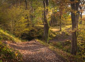
Ceredigion
Part of 'Spirit of the Miners' Walks
Open fields, steep woodland trails, 3 river crossings
Start/Finish: SN738767 - Devils Bridge
Suitable for: Moderately fit walkers
Grade: Moderate
Distance: 110K/6M
Time: 3hrs
Ceredigion
Part of Llandysul Trails - Llandysul / Pont-Tyweli South Walk
Start: SN418406 - Car Park, Llandysul
Suitable for: Moderately fit walkers
Grade: Moderate
Distance: 9km/5.6M
Time: 2.5hrs (excluding rest stops)
Ceredigion
Cors Caron is a vast wetland near Tregaron. The huge raised peat bogs and surrounding habitats support a wealth of wildlife. Accessible boardwalk over bog to hide, and Sustrans National Cycle route for walkers, cyclists and horse riders.

© Visit Mid Wales 2025. All Rights Reserved

 to add an item to your Itinerary basket.