To provide you with the best experience, cookies are used on this site. Learn more

To provide you with the best experience, cookies are used on this site. Learn more


Number of results: 157
, currently showing 61 to 80.
")
Cardigan
Picturesque remains that include a pair of highly defensible round towers dating to the first half of the thirteenth century. Earlier Norman origins.

Ceredigion
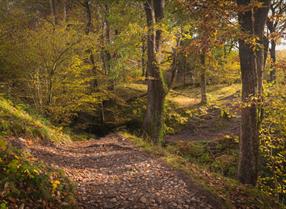
Pontrhydfendigaid Linear Trail Section 4
Distance & time: 18km (11 miles); 5½ hours
Terrain: Rough tracks, forestry, steep hill paths and riverside walks through mixed woodland
Grade: Strenous
Ceredigion
Part of Llandysul Trails -Coed y Foel Woodland & Countryside Walk
Start: SN418406 - Car Park, Llandysul
Suitable for: Moderately fit walkers
Grade: Moderate
Distance: 9km/5.6M
Time: 3 hours (excluding rest stops)
Ceredigion
The beach at Llanrhystud is a narrow shingle bank at high tide, but at low tide it becomes wide and sandy.

Cardigan
A 350 acre reserve with a difference. Wildlife of wetland, wood and meadow is conserved, whilst also being made accessible to the public along different footpaths.
Near Newcastle Emlyn
Follow a self guided walk around the village of Drefach Felindre highlighting historical and interesting facts about the woollen industry in the locality.
New Quay
Cwmtydu is an attractive, quiet beach that was once a harbour used as a traditional smugglers’ hideaway.
Ceredigion
Part of Llandysul Trails - Teifi Loop Walk
Start: SN418406 - Car Park, Llandysul
Suitable for: Moderately fit walkers
Grade: Moderate
Distance: 5.63km/3.5M
Time: 2.5 hours (excluding rest stops)
Aberystwyth
Quieter than the town's North Beach, Aberystwyth's long South Beach is sandwiched between the town's castle and the harbour breakwater. Tanybwlch Beach is south of Aberystwyth harbour
Cardigan
Mwnt, about 4.5 miles from Cardigan, is named after the conical hill (Foel y Mwnt) that rises above this popular beach. It is an ideal place to spot bottlenose dolphins, basking sharks and porpoises in the distance!
Ponterwyd, Aberystwyth
Bwlch Nant yr Arian is famous for feeding red kites daily. Range of waymarked walking, mountain biking, running and horse-riding trails and a mountain bike skills park. Café, shop and play area.
Llandysul
Llandysul Paddlers Canoe Centre is based near Carmarthen in West Wales.
Ystrad Meurig - Tregaron
The Ystwyth Trail is a 32.1km/20M cycle route and footpath linking Aberystwyth and Tregaron. Part of the trail follows the track of the old Great Western railway line.
Start: Aberystwyth SN584812
Finish: Tregaron SN679597
Welcome to Aberystwyth - a beautiful and lively seaside town on the Mid Wales coast. Enjoy stunning natural beauty, cultural attractions, unique shopping and dining, and a range of accommodation options. Easily accessible by railway, bus, or car,…
Ceredigion
Part of Tregaron Trails - Twm Town Walk
Start / Finish: Talbot Hotel, Tregaron SN680597
Suitable for most walkers, energetic children. Dogs on lead round livestock.
Distance: 5.5km (3.5 miles)
Time: 2 hours
Devil's Bridge
Coed Rheidol is situated about 12 miles east of Aberystwyth. It occupies parts of both banks of the Afon Rheidol, upstream, and the south bank downstream of Devil's Bridge.
Ceredigion
Cors Caron is a vast wetland near Tregaron. The huge raised peat bogs and surrounding habitats support a wealth of wildlife. Accessible boardwalk over bog to hide, and Sustrans National Cycle route for walkers, cyclists and horse riders.
Nestling on the banks of the river Teifi, Llandysul is a traditional unspoilt small market town.
Cilgerran is on the border of Ceredigion and Pembrokeshire between St Dogmaels and Cenarth. The village is linear in nature and stretches along the south bank of the Teifi River.
Pontrhydfendigaid
Llyn Teifi is the largest of a group of six pools and reservoirs in Mid Wales in the western edge of the Cambrian Mountains. The area is a Dark Skies Discovery site and the nearest village is Pontrhydfendigaid which is close to the site of Strata…

© Visit Mid Wales 2025. All Rights Reserved

 to add an item to your Itinerary basket.