About
Bwlch Nant yr Arian Visitor Centre sits at the head of a dramatic valley and has commanding views of Cardigan Bay and the Cambrian Mountains.
It is well-known for its long established tradition of daily feeding of red kites, Wales’s National Bird of Prey and there are trails for walkers, mountain bikers, and runners which are waymarked from the visitor centre.
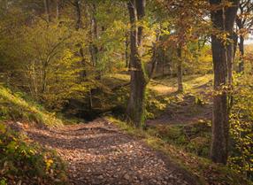
All of the beautiful scenic walking trails start from the visitor centre.
MINERS' TRAIL (1.5 miles, 2.4 kilometres)
The Miners Trail winds along the head of the valley, following a leat which once carried water to power lead mines. It climbs a short but steep hillside towards the Giant’s Chair, a great place to take in the view. It then drops down across a forest road and into an area which has recently been planted with 12,...Read More
About
Bwlch Nant yr Arian Visitor Centre sits at the head of a dramatic valley and has commanding views of Cardigan Bay and the Cambrian Mountains.
It is well-known for its long established tradition of daily feeding of red kites, Wales’s National Bird of Prey and there are trails for walkers, mountain bikers, and runners which are waymarked from the visitor centre.
All of the beautiful scenic walking trails start from the visitor centre.
MINERS' TRAIL (1.5 miles, 2.4 kilometres)
The Miners Trail winds along the head of the valley, following a leat which once carried water to power lead mines. It climbs a short but steep hillside towards the Giant’s Chair, a great place to take in the view. It then drops down across a forest road and into an area which has recently been planted with 12,000 native trees on its way back to the visitor centre.
BARCUD TRAIL (⅔ mile, 1.2 kilometres)
The Barcud Trail includes Animal Puzzle Trail and Elenydd Trail and leads you around the edge of the lake where the daily feeding of the red kites takes place (the Welsh for red kite is “Barcud Coch”). It is a circular level route suitable for wheelchairs and pushchairs.
Along the route there are wooden animals to spot - pick up an Animal Puzzle Trail leaflet from the dispenser or in the visitor centre and see how many animals you can find. Look out for sculptures and poetry along the path which bring local folklore and history to life – pick up an Elenydd Trail leaflet in the visitor centre.
RIDGETOP TRAIL (2.5 miles, 4.1 kilometres)
Follow the waymarkers up onto the heather clad ridge and enjoy the views of Cardigan Bay and the Cambrian Mountains. Head past the stone viewpoint before dropping down through the trees. Join the narrow leat path which brings you back to the car park.
Read Less


 to add an item to your Itinerary basket.


