Book Tickets Online
About
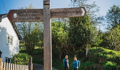
The 135 m/217km Glyndwr's Way National Trail is a long distance walk which can be enjoyed as a continuous journey, typically taking around nine days, or over a series of weekend or day trips. It begins at Knighton on the English border and meanders through the open moorland, rolling farmland, woodland and forest of Mid Wales, through the town of Machynlleth, which was the capital of Wales in 1404, finishing by the Montgomeryshire Canal in Welshpool. Here Glyndwr's Way is about three miles from Offa's Dyke Path National Trail, which can be followed all the way back to Knighton, adding about 30 miles to the walk.
Along the Trail are some of the finest landscape features in Wales including the tranquil Radnorshire Hills, the shores of the Clywedog Reservoir and heather clad Plynlimon. There are spectacular views over Cadair Idris, Lake Vyrnwy, the Cambrian Mountains and Y Golfa. The route reaches its highest point at Foel Fadian (1530ft/510m) from which on a clear day views stretch out along the majestic Dulas valley to Machynlleth and the sea.
The National Trail has been developed primarily for walkers, although there are sections suitable for horses and cyclists. However, Glyndwr's Way is not suitable for use as a long distance bridleway or cycle route.
The Glyndwr’s Way National Trail can be completed in sections, although it is important to always plan your accommodation or transport in advance as services are scarce along much of the Trail. Users of the Trail can walk sections of any length to suit their own needs but the following is an example, covering the Trails in stages.
Llanwddyn to Meifod. 15 miles/ 24km.
This section marks the end of the more arduous moorland part of the Trail. It is quite easy from now on, passing through pretty valleys, gentle farmland and along pleasant riverside walks.The Trail takes on a watery theme, leaving the Lake Vyrnwy reservoir behind but visiting wonderful sections of the River Vyrnwy.
The Dolanog to Meifod section (7m / 11km) of the route shadows the Vyrnwy as it undulates through woods, continuing through gentle farmland before crossing the edge of the wooded slopes of Gallt yr Ancr (Hill of Anthracite) It passes through three lovely villages on the river before stopping in the fourth river village of Meifod.
Meifod to Welshpool. 11 miles/ 17.5km.
The final day of the Trail starts in woodland and meanders quietly towards the trig point on the great hill of Y Golfa, with spectacular 360-degree views. Then the long, easy descent through the fine parkland of Llanerchydol Hall to the market town of Welshpool.
On leaving Meifod you encounter a steep but pleasant climb through woods of Broniarth Hill before looping round Llyn Du (Llyn means lake in Welsh). More comfortable farmland walking will eventually lead you to Y Golfa and on to Welshpool’s Raven Square. Glyndwrs Way reaches its end in a garden beside the canal bridge in Welshpool, where it links with the Severn Way regional route.
Powis Castle, half a mile from Welshpool is also worth a visit. Built in the 13th century the castle features impressive terraced gardens, an orangery, an aviary and a smattering of statues. It also houses the Clive of India museum.
Book Tickets
Facilities
Routes
- Countryside
- Long Distance Path


 to add an item to your Itinerary basket.


