About
This walk is a continuation of the walk to Pen Cerrig-calch. The walk is approximately 8 miles and you need to allow at least 5.5hours if starting from the car park in Crickhowell.
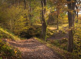
To walk to Pen Allt-mawr (Grid Ref: SO207242) from Crickhowell follow the directions to Pen Cerrig calch and continue on passed the trig point in a north easterly direction. The path leads to the lip of Pen Cerrig calch. It's a bit of a scramble down, but the path soon evens out as you head for Pen Allt-mawr. If you take a bearing at this stage on Pen Allt-mawr, you'll need to bear in mind that the path makes a wide arc westwards round to the trig point on the summit. In poor visibility
View north east from SO215226, between Pen Cerrig calch and Pen Allt-mawr you need to ensure that you don't leave the...Read More
About
This walk is a continuation of the walk to Pen Cerrig-calch. The walk is approximately 8 miles and you need to allow at least 5.5hours if starting from the car park in Crickhowell.
To walk to Pen Allt-mawr (Grid Ref: SO207242) from Crickhowell follow the directions to Pen Cerrig calch and continue on passed the trig point in a north easterly direction. The path leads to the lip of Pen Cerrig calch. It's a bit of a scramble down, but the path soon evens out as you head for Pen Allt-mawr. If you take a bearing at this stage on Pen Allt-mawr, you'll need to bear in mind that the path makes a wide arc westwards round to the trig point on the summit. In poor visibility
View north east from SO215226, between Pen Cerrig calch and Pen Allt-mawr you need to ensure that you don't leave the ridge running the length of the walk between the two summits of Pen cerrig calch and Pen Allt-mawr.
Once at Pen Allt-mawr you need to retrace your steps to Crickhowell (there are few direct alternatives). The walk to Pen Allt-mawr is on the other hand for more experienced and fit walkers, the first leg on a much bigger 20 mile-plus circuit which takes in Waun Fach (Grid Ref: SO217300), Pen Twyn Mawr (Grid Ref: SO243268), Crug Mawr (Grid Ref: SO262227) and Llanbedr (Grid Ref: SO240204). You need good weather, excellent boots and long day length (i.e. only try this in the summer).
Read Less

 to add an item to your Itinerary basket.