About
Both this walk and the one following to Pen Allt-mawr are more demanding walks.
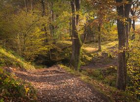
The walk up to Pen Cerrig-calch (701 meters) is approximately 5.5 miles from the car park in Crickhowell, but it does include some pretty steep stretches, especially the last section up onto what is a plateau on which the trig point (Grid Ref: SO217224) stands.
Allow at least 4.5 hours. A compass is needed because both the changeable conditions up on the top and also because the domed plateau on the top can be disorientating if your visible reference points are lost in the clouds.
Start the walk in the pay and display car park and follow the directions for getting up Table Mountain. Instead of turning up to the top of the Table Mountain once up on the shoulder of the hill, continue on the more gently...Read More
About
Both this walk and the one following to Pen Allt-mawr are more demanding walks.
The walk up to Pen Cerrig-calch (701 meters) is approximately 5.5 miles from the car park in Crickhowell, but it does include some pretty steep stretches, especially the last section up onto what is a plateau on which the trig point (Grid Ref: SO217224) stands.
Allow at least 4.5 hours. A compass is needed because both the changeable conditions up on the top and also because the domed plateau on the top can be disorientating if your visible reference points are lost in the clouds.
Start the walk in the pay and display car park and follow the directions for getting up Table Mountain. Instead of turning up to the top of the Table Mountain once up on the shoulder of the hill, continue on the more gently rising path and head for the shoulder of the main hill in front of you. Set a compass bearing on the Spring (Trwyn Ysgwrfa) marked on the OS map at Grid Ref: SO225214. The climb is fairly arduous right up on to the top so take it steadily. Once at the spring, the path twists round a rocky outcrop and continues up towards a summit. The path now becomes indistinct and the whole landscape becomes rocky and between the rocks, marshy. Set a compass bearing on the trig point which is invisible over the brow of the hill until you are only a few hundred yards away from it.
The views from the trig point are stunning. Now you have a choice to either continue along the top towards Pen Allt-mawr (Grid Ref SO207244) or to descend back down to Crickhowell by retracing your journey up. There are no real alternative routs back down to the village from Pen Cerrig-calch. The Sugar Loaf mountain to the east south east is a useful marker to guide the first part of the walk back down, but if it's cloudy, take another compass reading based on the spring at Trwyn Ysgwrfa to get you off the top safely.
Read Less

 to add an item to your Itinerary basket.