To provide you with the best experience, cookies are used on this site. Learn more

To provide you with the best experience, cookies are used on this site. Learn more

To build your own Itinerary, click  to add an item to your Itinerary basket.
Already saved an Itinerary?


You’re into tasting local delicacies and wandering small seaside towns or villages?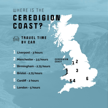 Tick.
Tick.
Walking a vast coastline and taking in the tranquil wildlife is more your thing? Great.
Adrenaline and big swells feature heavily in your vocabulary? Nice, we’re fluent.
Mid Wales has one of the largest and finest shorelines in the UK and the Wales Coast Path hugs the coast which means we have a whole lot to offer.
Its Mid Wales' authenticity that makes it a really big deal, and that means the hardest decision you’ll ever have to make while visiting is: “What’s next?”
Whatever you look for in a retreat, rest assured – this is where you’ll find it.
Aberystwyth is a University town and the largest town in Mid Wales, home to the National Library of Wales. For the best view of the town climb the steep Constitution Hill, either on foot or aboard the Aberystwyth Cliff Railway; the longest funicular electric railway in Britain.
New Quay is a picturesque town on the Mid Wales coast. From the harbour, you can see the famous Cardigan Bay dolphins most days in the summer.
Aberaeron's Georgian architecture was deemed so picturesque that it was featured on postage stamps. This fishing village is world famous for the quality of its honey (plus honey ice-cream and honey mustard produced locally) and also features prominently on the Dylan Thomas trail.
In Cardigan, the town's buildings are predominately Georgian and Victorian in style, many of which are in use as boutiques, traditional shops, inns and places to eat and drink. There is a wealth of local food producers in the surrounding area, and their produce is found on many menus throughout the town.
Aberystwyth is the largest town on the bay, with a university, seafront and castle. Aberaeron has a Georgian harbour and a growing food scene. New Quay is the best place for dolphin watching. Cardigan has a restored castle and the Teifi valley. Borth has a submerged forest and Ynyslas dunes.


Number of results: 158
, currently showing 121 to 140.
New Quay
New Quay’s Harbour Beach has stunning golden sands to rival any and has become a favourite for fishing and water sports enthusiasts. New Quay’s other beaches are Dolau & Traeth Gwyn.

Aberaeron
Get ready for a fantastic family day out at the Aberaeron Vintage Show! Set against the stunning backdrop of the Llanerchaeron estate, this event is a celebration of all things vintage.


Aberporth
2nd section of the Ceredigion Coastal Path
Total distance 18.7km 11.7 miles
Cardigan to Gwbert 5.6km (3.5 miles), grade/easy
Gwbert to Mwnt 5.8km (3.6 miles), grade/easy
Mwnt to Aberporth 8km (5 miles), grade/moderate
Ceredigion
Start: Tal-y-bont village green
Grid Reference: SN 654 891
Distance: 3.1 km – 1.9 miles
Grade: Easy/moderate
Terrain: Tarmac road and grassy tracks. Can be muddy
Maps: OS Explorer – 213
Ceredigion
The beach at Llanrhystud is a narrow shingle bank at high tide, but at low tide it becomes wide and sandy.
Set picturesquely overlooking two sandy beaches, the resort village of Aberporth is one of West Wales' most favoured family holiday locations. The beach is a regular recipient of Blue Flag and Seaside awards.
Borth
Borth's sandy beach is the longest in Ceredigion. With three miles of gently shelving golden sand this Blue Flag Beach is especially popular with families with younger children and sailboard enthusiasts.
Aberaeron
This spring, treat your little ones to a world of adventures around the grounds at Llanerchaeron on our Easter adventures in nature trails.
Cardigan - Borth
The Ceredigion Coast section of the Wales Coast Path providers the walker with glimpses of dolphins and porpoise, seals and a host of marine birds throughout the year around the majestic sweep of Cardigan Bay .
Aberystwyth
The Aberystwyth and Ceredigion County Show is an annual agricultural show and is a fun day out for all the family.
New Quay
A visit to New Quay is all about sandy beaches that extend in an arc around the bay, the harbour where boat trips will take you dolphin spotting in Cardigan Bay, and the great Welsh poet, Dylan Thomas enjoyed a few pints in the local.
Aberystwyth
Aberystwyth's North Beach and seafront is a focal point of the town and a favourite attraction for visitors and locals alike.
Aberystwyth
Aberystwyth bus station is next to the railway station with services from/to London, Cardiff, Carmarthen, Bangor, Haverfordwest, Fishguard and Cardigan.
Llangrannog is one of Ceredigion's favourite seaside resorts, seven miles south of New Quay. Its award winning sandy beaches nestle below the cliffs and are crossed by the Ceredigion section of the Wales Coast Path.
Aberystwyth
The Arts Centre can cater for events and conferences up to the capacity of 900 people.
Award winning Aberystwyth Arts Centre is Wales’ largest arts centre and recognised as a 'national flagship for the arts'.
Cardigan
Mwnt, about 4.5 miles from Cardigan, is named after the conical hill (Foel y Mwnt) that rises above this popular beach. It is an ideal place to spot bottlenose dolphins, basking sharks and porpoises in the distance!
Borth
Borth railway station is on the Cambrian Line from Shrewsbury to Aberystwyth.
Aberporth
The small village of Tresaith, just to the east of Aberporth, overlooks this attractive sandy beach; popular for sailing and surfing; there are rock pools to explore and even a waterfall.
Ceredigion
In the marvellous sweep of Cardigan Bay stand the ruins of one of Edward I's late 13th century castles. Of the seven major English strongholds he established in Wales, Aberystwyth Castle has fared least favourably in the survival stakes.
Aberaeron is one of Wales's most stylish coastal towns. It is on the Ceredigion coast and the Wales Coast Path is accessible from the town. Sited at the mouth of the river Aeron, the harbour operated as a port in the 19th century and steam ships…

© Visit Mid Wales 2026. All Rights Reserved

