About
Knighton is a market town located in the heart of the Mid Wales Marches. The name Knighton translates as Tref-y-Clawdd, which means Town on the Dyke and refers to the fact the Knighton is the only town to be built on Offa's Dyke.
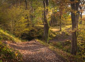
The area around Knighton in Powys is perfect walking country. Knighton is unique in Wales in that two National Trails meet - Offa's Dyke Path and Glyndwr's Way. The accolade of two National Trails is just a small indication of the profusion of walking opportunities in the area including a Circular Route which traces the famous earthwork of Offa’s Dyke, crosses the valley of the River Teme and follows the Heart of Wales Line Trail from Knucklas, climbing steeply back into the hills. Link with the course of Glyndŵr’s Way to walk through a pleasant...Read More
About
Knighton is a market town located in the heart of the Mid Wales Marches. The name Knighton translates as Tref-y-Clawdd, which means Town on the Dyke and refers to the fact the Knighton is the only town to be built on Offa's Dyke.
The area around Knighton in Powys is perfect walking country. Knighton is unique in Wales in that two National Trails meet - Offa's Dyke Path and Glyndwr's Way. The accolade of two National Trails is just a small indication of the profusion of walking opportunities in the area including a Circular Route which traces the famous earthwork of Offa’s Dyke, crosses the valley of the River Teme and follows the Heart of Wales Line Trail from Knucklas, climbing steeply back into the hills. Link with the course of Glyndŵr’s Way to walk through a pleasant woodland on the way back to Knighton. (Distance: 7.4 miles/11.9 km)
Knighton Community Market is held in the Community Centre hall on the second and fourth Saturdays of every month from 9.30am to 12.30pm, with ample parking just yards away. Fruit and vegetables, meat, bread and cakes are on offer, together with a wide variety of interesting craft items such as jewellery, art prints and personalised items, wall art and more. The market cafe serves tea, coffee, juice and snacks plus bacon baps and toasties.
Local events include a regular Farmers Market and the Knighton Show and Carnival held in August.
Knighton is rich in history with half-timbered houses, winding streets known locally as "The Narrows". There is evidence of settlement in the area dating back to the Stone Age but the current town is mostly medieval in origin.
OFFA'S DYKE NATIONAL TRAIL AND GLYNWR'S WAY NATIONAL TRAIL
Offa's Dyke was built toward the end of the 8th Century by King Offa to separate the kingdoms of Mercia from Wales. It ran for 149 miles from Chepstow to Prestatyn and some 80 miles of The Dyke is still traceable today.
Whether you want to potter along gentle paths and country lanes, nordic walk or strike out through the high country on Glyndwr's Way you will find what you want here. It's a great place from which to start - or finish an expedition along the Offas Dyke Path or Glyndwr's Way National Trails and a visit to the Offa's Dyke Visitor Centre on West Street is a must.
CYCLE ROUTES
For leisure cyclists, Knighton provides access to some of the loveliest day cycling in Wales. Information packs are available from Offa's Dyke Centre featuring easy-to-follow maps and written route instructions. Circular rides range from 9 to 33 miles (15 to 55km) in length.
STARGAZING & DARK SKIES
Other Knighton attractions include the Spaceguard Centre, an independent observatory which monitors the potential threat to our planet posed by 'near earth objects'.
Knighton has a railway station on the Heart of Wales line that runs from Shrewsbury to Swansea.
Pay & Display Car Parks: Norton Arms LD7 1DW - short stay - motorcars only; Bowling Green Lane LD7 1DJ - long stay.
Read Less

 to add an item to your Itinerary basket.