To provide you with the best experience, cookies are used on this site. Learn more

To provide you with the best experience, cookies are used on this site. Learn more


Number of results: 160
, currently showing 61 to 80.

Waunfawr, Aberystwyth
Driver guided tours for four people using a Ford Edge SUV. Airport collections included. Let Mid Wales Tours know what your interests are, and Sean will construct a tour to suit. Be it castles, mountains, lakes, churches, gardens or any of the other…


Lon Cambria is a 113-mile cycle route in the National Cycle Network which runs from Aberystwyth on the west coast of Wales, through the Cambrian Mountains and the Mid Wales Marches to Shrewsbury.
Ponterwyd, Aberystwyth
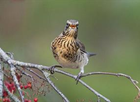
Perched on a hilltop near Aberystwyth, Bwlch Nant yr Arian is famous for feeding red kites daily. Range of waymarked walking, mountain biking, running and horse-riding trails and a mountain bike skills park. Café, shop and play area.
Aberystwyth
Devil's Bridge Falls is a spectacular waterfall attraction at Devil's Bridge in the heart of the Mid Wales' Cambrian Mountains.
Gilfachreda, New Quay
Dolphin Survey Boat Trips based in New Quay on the Mid Wales Coast, operate a choice of Boat Trips from 1 hour, 2 hours, 4 hours or all day.
nr Aberystwyth
The Visitor Centre and Cafe includes an interactive display about renewable energy, local films and guided tours of the centre at set times. The cafe offers a choice of light lunches, sandwiches and snacks.
Aberystwyth
A fun day for the whole family, situated in the heart of the beautiful Mid Wales Countryside. Lamb feeding, milking demonstrations, and much more.
Cilgerran is on the border of Ceredigion and Pembrokeshire between St Dogmaels and Cenarth. The village is linear in nature and stretches along the south bank of the Teifi River.

Ceredigion
Part of Llandysul Trails - Llandysul / Pont-Tyweli South Walk
Start: SN418406 - Car Park, Llandysul
Suitable for: Moderately fit walkers
Grade: Moderate
Distance: 9km/5.6M
Time: 2.5hrs (excluding rest stops)
Ceredigion
The beach at Llanrhystud is a narrow shingle bank at high tide, but at low tide it becomes wide and sandy.
Aberporth
2nd section of the Ceredigion Coastal Path
Total distance 18.7km 11.7 miles
Cardigan to Gwbert 5.6km (3.5 miles), grade/easy
Gwbert to Mwnt 5.8km (3.6 miles), grade/easy
Mwnt to Aberporth 8km (5 miles), grade/moderate
Llangrannog
3rd section of the Cerdigion Coastal Path
Total distance 15km (9.4 miles)
Llangrannog to Cwm Tydu 9.4km (5.9 miles), grade/moderate
Cwm Tydu to New Quay 5.6km (3.5 miles, grade/moderate
Ponterwyd, Aberystwyth
Mid Wales is a serious stop off and venue for people wishing to improve their dirt jump and pump track skills and the Mountain Bike Skills Park at Bwlch Nant yr Arian equips people to more safely enjoy their cycling out on the existing mountain bike…
Ceredigion
Start: Tal-y-bont village green
Grid Reference: SN 654 891
Distance: 3.1 km – 1.9 miles
Grade: Easy/moderate
Terrain: Tarmac road and grassy tracks. Can be muddy
Maps: OS Explorer – 213
Cardigan - Aberporth
1st section of the Ceredigion Coastal Path
Total distance 18.7km (11.7 miles)
Cardigan to Gwbert 5.6km (3.5 miles), grade/easy
Gwbert to Mwnt 5.8km (3.6 miles), grade/easy
Mwnt to Aberporth 8km (5 miles), grade/moderate
Pontrhydfendigaid
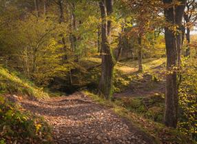
Coed y Bont is a community woodland situated on the edge of the village of Pontrhydfendigaid in the foothills of the Cambrian Mountains. The woodland is recognised as a Dark Sky Discovery Site.
Cardigan
Mwnt, about 4.5 miles from Cardigan, is named after the conical hill (Foel y Mwnt) that rises above this popular beach. It is an ideal place to spot bottlenose dolphins, basking sharks and porpoises in the distance!
Ponterwyd, Aberystwyth
Bwlch Nant yr Arian Visitor Centre sits at the head of a dramatic valley and has commanding views of Cardigan Bay and the Cambrian Mountains. Expect beautiful scenic walking trails all of which are waymarked and start from the visitor centre.
Aberaeron
Aberaeron South Beach is a rock and shingle beach just to the south of the town and harbour.
Ponterwyd, Aberystwyth
Bwlch Nant yr Arian is famous for feeding red kites daily. Range of waymarked walking, mountain biking, running and horse-riding trails and a mountain bike skills park. Café, shop and play area.

© Visit Mid Wales 2025. All Rights Reserved

 to add an item to your Itinerary basket.